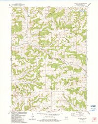
1983 Map of Kendall West
USGS Topo · Published 1984About this map
The divide between the Baraboo River and the Kickapoo River systems defines this 1983 survey of Monroe County. High ridges like Dorset Ridge and South Ridge separate deep-cut valleys such as Cold Spring Valley and Fox Valley. In the southeast, the village of Kendall marks a key point on the landscape, connected to the western terrain by the Elroy-Sparta State Trail, which follows an old rail alignment through Tunnel No 1. Cultural landmarks dot the rural sections, including St Matthew Ch and its accompanying St Matthew Cem near Pleasant Ridge, while the Dorset Ridge Sch remains a focal point for the uplands. Dozens of small quarries and gravel pits throughout the townships of Wilton and Wellington reflect the local extractive industry that supported the development of road networks like Drysdale Avenue.
Find a feature on this map
70 named features on this map. Tap any name to fly to it.
Don’t see what you’re looking for? This feature index may not catch every label — zoom into the map to look around manually.
Map Details
Editions of this 1983 Kendall West Map
This is the sole edition of this map. No revisions or reprints were ever made.
Other maps of this area

1916 · Tomah
USGS Topo · 1:62,500

1919 · Kendall
USGS Topo · 1:62,500

1921 · Kendall
USGS Topo · 1:62,500

1926 · La Farge
USGS Topo · 1:62,500

1927 · Hillsboro
USGS Topo · 1:62,500

1949 · Tomah
USGS Topo · 1:62,500

1958 · La Crosse
USGS Topo · 1:250,000

1961 · La Crosse
USGS Topo · 1:250,000

1962 · Kendall
USGS Topo · 1:62,500

1965 · La Crosse
USGS Topo · 1:250,000