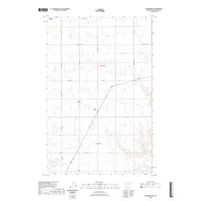
2020 Map of Kenilworth SW
USGS Topo · Published 2020About this map
Twelvemile Coulee and Spring Coulee cut through the northern reaches of this Big Sky landscape, defining a terrain shaped by erosion and seasonal drainage. This portion of Chouteau County is characterized by a sprawling network of rural roads that follow section lines and topography, including Rudyard Rd and Mc Keever Rd. The southern portion of the quadrangle is bisected by the diagonal path of Broadway, which traverses between Dry Fork Coulee and Sixmile Coulee. The map provides a detailed view of land divisions within Townships t27n r10e and t26n r10e, revealing a pattern of agricultural development where family-named thoroughfares like Stranahan Rd, Briese Rd, and Lippard Rd serve isolated farmsteads. This 2020 survey documents the enduring spatial logic of Montana's high plains, where watercourses and section-line roads remain the primary landmarks for navigation and land management.
Find a feature on this map
19 named features on this map. Tap any name to fly to it.
Don’t see what you’re looking for? This feature index may not catch every label — zoom into the map to look around manually.
Map Details
Editions of this 2020 Kenilworth SW Map
This is the sole edition of this map. No revisions or reprints were ever made.
Other maps of this area

1890 · Fort Benton
USGS Topo · 1:250,000

1892 · Fort Benton
USGS Topo · 1:250,000

1897 · Fort Benton
USGS Topo · 1:250,000

1906 · Lonesome
USGS Topo · 1:62,500

1919 · Big Sandy
USGS Topo · 1:125,000

1953 · Boggs Island
USGS Topo · 1:24,000

1953 · Loma East
USGS Topo · 1:24,000

1953 · Loma West
USGS Topo · 1:24,000

1953 · Stranahan
USGS Topo · 1:24,000

1954 · Great Falls
USGS Topo · 1:250,000