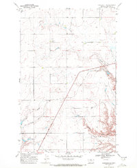
1969 Map of Kenilworth SW
USGS Topo · Published 1972About this map
Lewis and Clark Trail markers trace a historic path through this portion of Chouteau County, where the high plains are deeply incised by a series of drainage systems including Sixmile Coulee and Twelvemile Coulee. The landscape reveals a transition from traditional transport to modern aviation, evidenced by the presence of a Landing Area and the remnants of former infrastructure marked as Old RR Grade. These linear features cut across a terrain otherwise defined by natural drainages like Dry Fork Coulee and Spring Coulee. Small-scale human markers such as the Schlack triangulation station and an isolated Grave provide specific points of interest for researchers of local history and genealogy. The map effectively captures the vast, open character of this Montana region as it appeared in the late 1960s, balancing topographic natural features with the faint footprints of historical movement and early 20th-century development.
Find a feature on this map
10 named features on this map. Tap any name to fly to it.
Don’t see what you’re looking for? This feature index may not catch every label — zoom into the map to look around manually.
Map Details
Editions of this 1969 Kenilworth SW Map
This is the sole edition of this map. No revisions or reprints were ever made.
Other maps of this area

1890 · Fort Benton
USGS Topo · 1:250,000

1892 · Fort Benton
USGS Topo · 1:250,000

1897 · Fort Benton
USGS Topo · 1:250,000

1906 · Lonesome
USGS Topo · 1:62,500

1919 · Big Sandy
USGS Topo · 1:125,000

1953 · Boggs Island
USGS Topo · 1:24,000

1953 · Loma East
USGS Topo · 1:24,000

1953 · Loma West
USGS Topo · 1:24,000

1953 · Stranahan
USGS Topo · 1:24,000

1954 · Great Falls
USGS Topo · 1:250,000