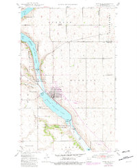
1948 Map of Kenmare
USGS Topo · Published 1982About this map
The city of Kenmare occupies a central position along the western shore of Middle Des Lacs Lake, surrounded by the extensive protected lands of the Des Lacs National Wildlife Refuge. This late 1940s topography shows a community deeply integrated with the water, where the Soo Line railroad cuts through the terrain near several coulees, including Ankenbauer Coulee and Niobe Coulee. Purple revision markings added later indicate the expansion of the Kenmare Municipal Airport and updated airfield infrastructure like the Badmer Landing Strip.
Find a feature on this map
22 named features on this map. Tap any name to fly to it.
Don’t see what you’re looking for? This feature index may not catch every label — zoom into the map to look around manually.
Map Details
Editions of this 1948 Kenmare Map
2 editions found
Other maps of this area

1947 · Tolley
USGS Topo · 1:62,500

1947 · Bowbells
USGS Topo · 1:24,000

1948 · Kenmare
USGS Topo · 1:24,000

1948 · Norma
USGS Topo · 1:24,000

1948 · Donnybrook
USGS Topo · 1:24,000

1949 · Mosquito Butte
USGS Topo · 1:24,000

1949 · Bowbells
USGS Topo · 1:24,000

1949 · Bowbells SE
USGS Topo · 1:24,000

1949 · Niobe
USGS Topo · 1:24,000

1949 · Coulee
USGS Topo · 1:24,000