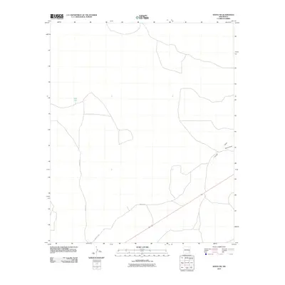
2010 Map of Kenna SW
USGS Topo · Published 2010About this map
Kelly Tank and the seasonal watercourses of eastern Chaves County define this high plains landscape as it appeared in the early 21st century. The map provides a look at the essential water management and transportation infrastructure necessary for ranching and travel in this arid region of New Mexico. Prominent drainage patterns such as Falsey Draw and Kenna Draw cross the terrain, illustrating the natural catchment systems that dictate land use in the area. Remote access is maintained through a network of local thoroughfares, including County RD-77 and Mesquite RD, which connect isolated water features to the broader region. This 2010 survey reflects the enduring character of the New Mexico landscape, where geography is primarily defined by names associated with local hydrology and the long-established ranching roads that traverse the basin.
Find a feature on this map
5 named features on this map. Tap any name to fly to it.
Don’t see what you’re looking for? This feature index may not catch every label — zoom into the map to look around manually.
Map Details
Editions of this 2010 Kenna SW Map
This is the sole edition of this map. No revisions or reprints were ever made.
Other maps of this area

1954 · Brownfield
USGS Topo · 1:250,000

1955 · Roswell
USGS Topo · 1:250,000

1958 · Brownfield
USGS Topo · 1:250,000

1958 · Roswell
USGS Topo · 1:250,000

1962 · Roswell
USGS Topo · 1:250,000

1962 · Brownfield
USGS Topo · 1:250,000

1967 · Elkins
USGS Topo · 1:24,000
1967 · Denton Camp
USGS Topo · 1:24,000
1967 · Olive
USGS Topo · 1:24,000

1978 · Curlew Lake
USGS Topo · 1:24,000