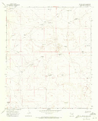
1967 Map of Denton Camp
USGS Topo · Published 1971About this map
Denton Camp and the Denton L 7 Ranch sit within a high-desert landscape defined by precarious water management in the late 1960s. This survey illustrates the specialized infrastructure of Chaves County ranching, where survival depends on a network of named catchment basins like Circle Y Tank, Sixmile Tank, and Weak Wells Tank. The map reveals the vital role of wind-driven power across the plains, marking numerous landmarks such as the Denton Windmills, Beatonbough Windmill, and Apache Windmill. One of the most distinctive features is the expanse of Shifting Sand, which moves across the terrain south of the ranching hubs. An industrial Pipeline and a sparse Jeep Trail network provide the primary transit and utility corridors through this arid region, where even small features like Salt Cedar Lake serve as critical navigational markers.
Find a feature on this map
32 named features on this map. Tap any name to fly to it.
Don’t see what you’re looking for? This feature index may not catch every label — zoom into the map to look around manually.
Map Details
Editions of this 1967 Denton Camp Map
This is the sole edition of this map. No revisions or reprints were ever made.
Other maps of this area

1954 · Brownfield
USGS Topo · 1:250,000

1955 · Roswell
USGS Topo · 1:250,000

1958 · Brownfield
USGS Topo · 1:250,000

1958 · Roswell
USGS Topo · 1:250,000

1962 · Roswell
USGS Topo · 1:250,000

1962 · Brownfield
USGS Topo · 1:250,000

1967 · Haystack Mountain
USGS Topo · 1:24,000

1967 · Hernandez Lake
USGS Topo · 1:24,000
1967 · Haystack Butte
USGS Topo · 1:24,000

1967 · Elkins
USGS Topo · 1:24,000