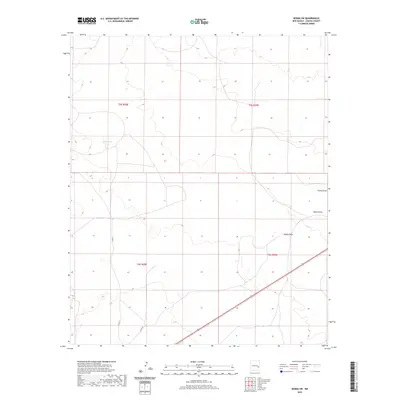
2020 Map of Kenna SW
USGS Topo · Published 2020About this map
Kelly Tank and the dry drainage beds of the High Plains characterize this corner of eastern Chaves County. This topographic study reflects the modern rural landscape, where water management is central to the local geography. The map traces the winding paths of Kenna Draw and Falsey Draw as they cut through the sectioned ranch land. Transportation is defined by the diagonal corridor of Highway 70 and a network of county routes including Co Rd 77 and Co Rd 46, which facilitate movement between the vast land divisions of t5s r29e and t6s r29e.
Find a feature on this map
10 named features on this map. Tap any name to fly to it.
Don’t see what you’re looking for? This feature index may not catch every label — zoom into the map to look around manually.
Map Details
Editions of this 2020 Kenna SW Map
This is the sole edition of this map. No revisions or reprints were ever made.
Other maps of this area

1954 · Brownfield
USGS Topo · 1:250,000

1955 · Roswell
USGS Topo · 1:250,000

1958 · Brownfield
USGS Topo · 1:250,000

1958 · Roswell
USGS Topo · 1:250,000

1962 · Roswell
USGS Topo · 1:250,000

1962 · Brownfield
USGS Topo · 1:250,000

1967 · Elkins
USGS Topo · 1:24,000
1967 · Denton Camp
USGS Topo · 1:24,000
1967 · Olive
USGS Topo · 1:24,000

1978 · Curlew Lake
USGS Topo · 1:24,000