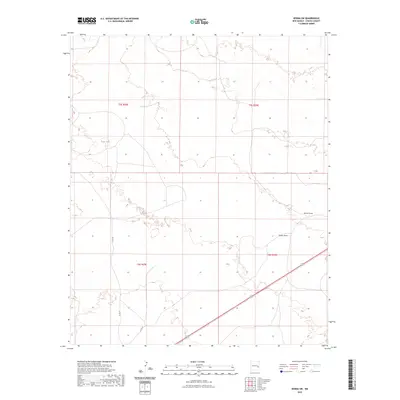
2023 Map of Kenna SW
USGS Topo · Published 2023About this map
Kenna Draw and Falsey Draw define the drainage patterns across this section of Chaves County, where the high plains landscape is marked by the infrastructure of ranching and remote travel. The presence of Kelly Tank indicates the essential role of water management in this arid region, providing a localized point of interest for those studying the livestock and land-use history of southeast New Mexico. The grid of the Public Land Survey System is clearly delineated, showing townships like t5s r29e and t6s r29e, which provide the geometric framework for property boundaries in the area. Transportation is limited to functional routes such as Co Rd 77 and Co Rd 46, reflecting the sparse settlement patterns and the vast distances characteristic of the Llano Estacado's western fringes.
Find a feature on this map
9 named features on this map. Tap any name to fly to it.
Don’t see what you’re looking for? This feature index may not catch every label — zoom into the map to look around manually.
Map Details
Editions of this 2023 Kenna SW Map
This is the sole edition of this map. No revisions or reprints were ever made.
Other maps of this area

1954 · Brownfield
USGS Topo · 1:250,000

1955 · Roswell
USGS Topo · 1:250,000

1958 · Brownfield
USGS Topo · 1:250,000

1958 · Roswell
USGS Topo · 1:250,000

1962 · Roswell
USGS Topo · 1:250,000

1962 · Brownfield
USGS Topo · 1:250,000

1967 · Elkins
USGS Topo · 1:24,000
1967 · Denton Camp
USGS Topo · 1:24,000
1967 · Olive
USGS Topo · 1:24,000

1978 · Curlew Lake
USGS Topo · 1:24,000