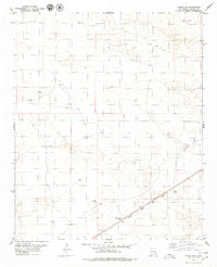
1979 Map of Kenna SW
USGS Topo · Published 1979About this map
The Atchison Topeka and Santa Fe railroad cuts a diagonal path through the southeastern corner of this Chaves County landscape, anchoring the region's transport network during the late 1970s. The terrain is defined by dry watercourses such as Kenna Draw and Falsey Draw, which cross an arid expanse marked by a sophisticated system of water management. Named water sources including the Ownby Well, Newlan Well, and Kelly Tank indicate the vital infrastructure necessary for ranching and livestock in this part of New Mexico. The presence of a Gravel Pit and a Drill Hole suggests localized resource extraction or geological exploration. A network of Jeep Trails provides access across the interior, connecting remote landmarks like North Well and Three Wells to the primary rail corridor.
Find a feature on this map
13 named features on this map. Tap any name to fly to it.
Don’t see what you’re looking for? This feature index may not catch every label — zoom into the map to look around manually.
Map Details
Editions of this 1979 Kenna SW Map
This is the sole edition of this map. No revisions or reprints were ever made.
Other maps of this area

1954 · Brownfield
USGS Topo · 1:250,000

1955 · Roswell
USGS Topo · 1:250,000

1958 · Brownfield
USGS Topo · 1:250,000

1958 · Roswell
USGS Topo · 1:250,000

1962 · Roswell
USGS Topo · 1:250,000

1962 · Brownfield
USGS Topo · 1:250,000

1967 · Elkins
USGS Topo · 1:24,000
1967 · Denton Camp
USGS Topo · 1:24,000
1967 · Olive
USGS Topo · 1:24,000

1978 · Curlew Lake
USGS Topo · 1:24,000