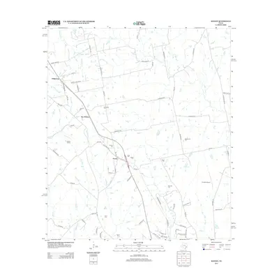
2013 Map of Kenney
USGS Topo · Published 2013About this map
Kenney and Phillipsburg anchor this rural Texas landscape, where a dense network of family and community history is preserved through numerous burial grounds. The map detail highlights an area defined by small settlements and the winding paths of Caney Cr and Buffalo Cr. Genealogists will find significant value in the distribution of family-named sites, including the Streb Cem, Pfeffer Cem, and Meinecke Cem, which speak to the area's ancestral roots. Transportation is characterized by a transition from local roads like Old Phillipsburg Rd to the aviation infrastructure at Hinson Airport and P-K Ranch Airport. The topography is marked by small tributaries like Campbell Br and Ward Br, feeding into larger creek systems that have shaped the rural development of these New Wehdem environs.
Find a feature on this map
78 named features on this map. Tap any name to fly to it.
Don’t see what you’re looking for? This feature index may not catch every label — zoom into the map to look around manually.
Map Details
Editions of this 2013 Kenney Map
This is the sole edition of this map. No revisions or reprints were ever made.
Other maps of this area

1930 · Brenham
USGS Topo · 1:62,500

1953 · Seguin
USGS Topo · 1:250,000

1954 · Austin
USGS Topo · 1:250,000

1956 · Bellville
USGS Topo · 1:62,500

1956 · Sealy
USGS Topo · 1:62,500

1956 · Hempstead
USGS Topo · 1:62,500

1956 · Brenham
USGS Topo · 1:62,500

1958 · Seguin
USGS Topo · 1:250,000
1961 · Burleigh
USGS Topo · 1:24,000
1961 · Daniels
USGS Topo · 1:24,000