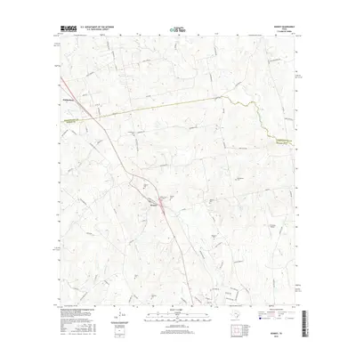
2016 Map of Kenney
USGS Topo · Published 2016About this map
Kenney and Phillipsburg sit at the center of this modern landscape where the boundary between Washington County and Austin County divides rolling rural acreage. The region is marked by an extensive collection of family and community burial sites, including the Phillipsburg Cem, Pfeffer Cem, and Kaechele Cem, which offer significant touchstones for genealogical research. Local infrastructure is defined by a dense network of country roads such as Sempronius Rd and Kenney Hall Rd, which navigate around the numerous tributaries of Piney Creek and Caney Creek. A small private landing strip, the P-K Ranch Airport, and the presence of Cook Lake highlight the mix of agricultural utility and private land use. The map provides a clear look at the contemporary settlement patterns of these small Texas communities and their enduring rural character.
Find a feature on this map
78 named features on this map. Tap any name to fly to it.
Don’t see what you’re looking for? This feature index may not catch every label — zoom into the map to look around manually.
Map Details
Editions of this 2016 Kenney Map
This is the sole edition of this map. No revisions or reprints were ever made.
Other maps of this area

1930 · Brenham
USGS Topo · 1:62,500

1953 · Seguin
USGS Topo · 1:250,000

1954 · Austin
USGS Topo · 1:250,000

1956 · Bellville
USGS Topo · 1:62,500

1956 · Sealy
USGS Topo · 1:62,500

1956 · Hempstead
USGS Topo · 1:62,500

1956 · Brenham
USGS Topo · 1:62,500

1958 · Seguin
USGS Topo · 1:250,000
1961 · Burleigh
USGS Topo · 1:24,000
1961 · Daniels
USGS Topo · 1:24,000