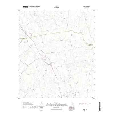
2019 Map of Kenney
USGS Topo · Published 2019About this map
Kenney sits along the shared border of Washington and Austin Counties, serving as a focal point for a rural landscape defined by family legacies and creek drainages. The map reveals a high density of burial grounds that speak to the area's genealogical depth, including the Pfeffer Cem and Pfeffer Cem Number 3, as well as the Montgomery Cem and Kaechele Cem. North of Kenney, the settlement of Phillipsburg is located near the Phillipsburg Cem, situated between the headwaters of Buffalo Cr and Williams Cr. The terrain is deeply etched by a network of waterways like Caney Cr and Piney Cr, which dictate the winding paths of local routes such as Church Rd and Sempronius Rd. This survey highlights how modern infrastructure, like the P-K Ranch Airport, integrates into a region still largely shaped by its traditional agricultural and residential patterns.
Find a feature on this map
80 named features on this map. Tap any name to fly to it.
Don’t see what you’re looking for? This feature index may not catch every label — zoom into the map to look around manually.
Map Details
Editions of this 2019 Kenney Map
This is the sole edition of this map. No revisions or reprints were ever made.
Other maps of this area

1930 · Brenham
USGS Topo · 1:62,500

1953 · Seguin
USGS Topo · 1:250,000

1954 · Austin
USGS Topo · 1:250,000

1956 · Bellville
USGS Topo · 1:62,500

1956 · Sealy
USGS Topo · 1:62,500

1956 · Hempstead
USGS Topo · 1:62,500

1956 · Brenham
USGS Topo · 1:62,500

1958 · Seguin
USGS Topo · 1:250,000
1961 · Burleigh
USGS Topo · 1:24,000
1961 · Daniels
USGS Topo · 1:24,000