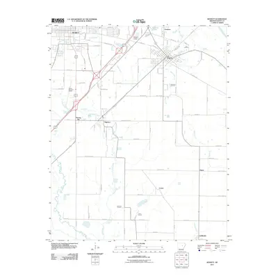
2011 Map of Kensett
USGS Topo · Published 2011About this map
The southeastern outskirts of Searcy and the nearby rail-aligned community of Kensett anchor this White County landscape. The map captures a transition from urban development and the industrial activity near Searcy Municipal Airport to the low-lying wetlands of the White River valley. The drainage patterns of Gin Creek and Black Creek define the local topography, while the north-south transport corridor connecting Higginson and Morning Sun illustrates the area's historical reliance on both rail and highway infrastructure. Smaller rural settlements such as Conant, Happy, and Griffithville dot the eastern and southern plains, marking early centers of local agriculture. Genealogists and historians will find several well-documented burial sites across the quadrangle, including Memorial Gardens Cemetery, Crow Cemetery, and Lessenberry Cemetery, providing a spatial record of the region's family lineages.
Find a feature on this map
92 named features on this map. Tap any name to fly to it.
Don’t see what you’re looking for? This feature index may not catch every label — zoom into the map to look around manually.
Map Details
Editions of this 2011 Kensett Map
This is the sole edition of this map. No revisions or reprints were ever made.
Other maps of this area

1932 · Kensett
USGS Topo · 1:62,500

1935 · Kensett
USGS Topo · 1:62,500

1935 · Bald Knob
USGS Topo · 1:62,500

1953 · Memphis
USGS Topo · 1:250,000

1956 · Memphis
USGS Topo · 1:250,000

1962 · Letona
USGS Topo · 1:24,000

1963 · Garner
USGS Topo · 1:24,000
1963 · Mc Rae
USGS Topo · 1:24,000
1964 · Walker
USGS Topo · 1:24,000
1964 · Kensett
USGS Topo · 1:24,000