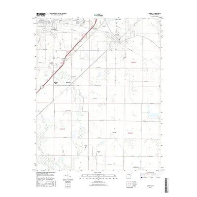
2017 Map of Kensett
USGS Topo · Published 2017About this map
Searcy serves as the primary urban center in this 2017 study of White County, anchored by the campus of Harding Univ and the Searcy Municipal Airport. The landscape transitions from the developed streets of Kensett and Higginson into a complex network of wetlands and creeks to the south and east. Water dominates the southern portion of the quadrangle, where the meandering course of Bayou Des Arc and Carsons Slough defines the terrain. Local history and genealogy are well-represented by several burial grounds, including Crow Cem and Liberty Cem. The eastern edge is bounded by the Little Red River, while smaller settlements like Happy and Griffithville mark the rural reaches. This map illustrates the intersection of mid-century infrastructure and the persistent natural watercourses of the Arkansas lowlands.
Find a feature on this map
108 named features on this map. Tap any name to fly to it.
Don’t see what you’re looking for? This feature index may not catch every label — zoom into the map to look around manually.
Map Details
Editions of this 2017 Kensett Map
This is the sole edition of this map. No revisions or reprints were ever made.
Other maps of this area

1932 · Kensett
USGS Topo · 1:62,500

1935 · Kensett
USGS Topo · 1:62,500

1935 · Bald Knob
USGS Topo · 1:62,500

1953 · Memphis
USGS Topo · 1:250,000

1956 · Memphis
USGS Topo · 1:250,000

1962 · Letona
USGS Topo · 1:24,000

1963 · Garner
USGS Topo · 1:24,000
1963 · Mc Rae
USGS Topo · 1:24,000
1964 · Walker
USGS Topo · 1:24,000
1964 · Kensett
USGS Topo · 1:24,000