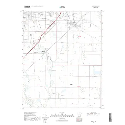
2020 Map of Kensett
USGS Topo · Published 2020About this map
The Little Red River flows through the northeastern corner of this landscape, while the sprawling campus of Harding University anchors the northeastern portion of Searcy. The map illustrates a transition from the urban grid of the county seat to the agricultural and wetland expanses of central Arkansas. A network of smaller settlements, including Higginson, Kensett, and Morning Sun, are linked by a dense web of transportation routes that follow the natural topography, notably avoiding the low-lying areas near Carsons Slough and Gum Springs Cr.
Find a feature on this map
95 named features on this map. Tap any name to fly to it.
Don’t see what you’re looking for? This feature index may not catch every label — zoom into the map to look around manually.
Map Details
Editions of this 2020 Kensett Map
This is the sole edition of this map. No revisions or reprints were ever made.
Other maps of this area

1932 · Kensett
USGS Topo · 1:62,500

1935 · Kensett
USGS Topo · 1:62,500

1935 · Bald Knob
USGS Topo · 1:62,500

1953 · Memphis
USGS Topo · 1:250,000

1956 · Memphis
USGS Topo · 1:250,000

1962 · Letona
USGS Topo · 1:24,000

1963 · Garner
USGS Topo · 1:24,000
1963 · Mc Rae
USGS Topo · 1:24,000
1964 · Walker
USGS Topo · 1:24,000
1964 · Kensett
USGS Topo · 1:24,000