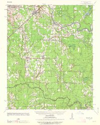
1935 Map of Kensett
USGS Topo · Published 1963About this map
White County farmland and river bottoms are documented here during the mid-1930s, showing a landscape defined by the winding course of the Little Red River and the broader White River. The Missouri Pacific railroad serves as the primary industrial corridor, connecting the established hubs of Searcy, Kensett, and Higginson. Outside these centers, a network of small schoolhouses and churches, such as Williams Sch and New Hope Ch, provides evidence of a rural population still deeply tied to local community nodes.
Find a feature on this map
53 named features on this map. Tap any name to fly to it.
Don’t see what you’re looking for? This feature index may not catch every label — zoom into the map to look around manually.
Map Details
Editions of this 1935 Kensett Map
2 editions found
Other maps of this area

1932 · Kensett
USGS Topo · 1:62,500

1935 · Kensett
USGS Topo · 1:62,500

1935 · Hazen
USGS Topo · 1:62,500

1935 · Augusta
USGS Topo · 1:62,500

1935 · Gregory
USGS Topo · 1:62,500

1935 · Bald Knob
USGS Topo · 1:62,500

1940 · Lonoke
USGS Topo · 1:62,500

1941 · Hazen
USGS Topo · 1:62,500

1941 · De Valls Bluff
USGS Topo · 1:62,500

1948 · Helena
USGS Topo · 1:250,000