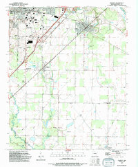
1994 Map of Kensett
USGS Topo · Published 1994About this map
The Searcy corporate boundary anchors the northwestern corner of this map, showcasing a transition from established urban infrastructure to the agrarian and rail-driven landscapes of White County. The Missouri Pacific Railroad cuts diagonally through the terrain, connecting the regional hub of Kensett with Higginson and smaller settlements like Morning Sun. Institutional landmarks are prominent, including Harding College and Harding Academy, alongside essential services like the Central Arkansas General Hospital. To the east, the Little Red River meanders near Doniphan, where Doniphan Lake sits just north of the rail line. The map is particularly rich for genealogical research, documenting numerous small burial grounds and rural places of worship, such as Lessenberry Cem, Crow Cem, and New Morrow Ch, which reflect the community's historical development and social fabric.
Find a feature on this map
47 named features on this map. Tap any name to fly to it.
Don’t see what you’re looking for? This feature index may not catch every label — zoom into the map to look around manually.
Map Details
Editions of this 1994 Kensett Map
This is the sole edition of this map. No revisions or reprints were ever made.
Other maps of this area

1932 · Kensett
USGS Topo · 1:62,500

1935 · Kensett
USGS Topo · 1:62,500

1935 · Bald Knob
USGS Topo · 1:62,500

1953 · Memphis
USGS Topo · 1:250,000

1956 · Memphis
USGS Topo · 1:250,000

1962 · Letona
USGS Topo · 1:24,000

1963 · Garner
USGS Topo · 1:24,000
1963 · Mc Rae
USGS Topo · 1:24,000
1964 · Walker
USGS Topo · 1:24,000
1964 · Kensett
USGS Topo · 1:24,000