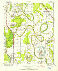
1939 Map of Keo
USGS Topo · Published 1954About this map
Plum Bayou snakes through this low-lying landscape south of Little Rock, defining the agricultural and settlement patterns of Lonoke and Pulaski Counties just before the mid-century. The intricate loops of the bayou, along with features like Big Cypress Brake and Clear Lake, illustrate the complex drainage and flood management system of the era, further evidenced by the Little Rock Gillett Levee running parallel to the Arkansas River.
Find a feature on this map
30 named features on this map. Tap any name to fly to it.
Don’t see what you’re looking for? This feature index may not catch every label — zoom into the map to look around manually.
Map Details
Editions of this 1939 Keo Map
3 editions found
Other maps of this area

1891 · Little Rock
USGS Topo · 1:125,000

1893 · Little Rock
USGS Topo · 1:125,000

1932 · Pastoria
USGS Topo · 1:62,500

1935 · Sweet Home
USGS Topo · 1:24,000

1935 · Altheimer
USGS Topo · 1:62,500

1935 · Pastoria
USGS Topo · 1:62,500

1937 · England
USGS Topo · 1:48,000

1939 · Keo
USGS Topo · 1:31,680

1940 · Woodson
USGS Topo · 1:31,680

1941 · Keo
USGS Topo · 1:31,680