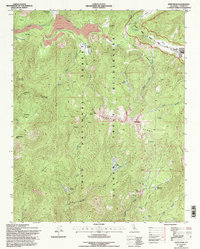
1994 Map of Kern Peak
USGS Topo · Published 1997About this map
Kern Peak dominates the high-altitude landscape of the Sierra Nevada Range in this mid-1990s survey. The area is defined by its complex drainage network, where the South Fork Kern River meets several significant mountain stringers including Lewis Stringer and Kern Peak Stringer. Evidence of the region's volcanic past is clear in labels such as Malpais, Lava, and Volcano Meadow, while the presence of the Tunnel FS Station near Tunnel Meadow indicates a history of forest management and early back-country administration. The map highlights a primitive landscape of meadows and peaks, from Groundhog Meadow to the Chinquapin Basin, preserved within the Golden Trout Wilderness and Inyo National Forest. High-elevation landmarks like Indian Head and Overlook Mountain overlook a network of trails and approximate locations that guided travelers before modern infrastructure reached this part of Tulare County.
Find a feature on this map
43 named features on this map. Tap any name to fly to it.
Don’t see what you’re looking for? This feature index may not catch every label — zoom into the map to look around manually.
Map Details
Editions of this 1994 Kern Peak Map
This is the sole edition of this map. No revisions or reprints were ever made.
Other maps of this area

1905 · Olancha
USGS Topo · 1:125,000

1907 · Olancha
USGS Topo · 1:125,000

1948 · Fresno
USGS Topo · 1:250,000

1955 · Fresno
USGS Topo · 1:250,000

1956 · Fresno
USGS Topo · 1:250,000

1956 · Hockett Peak
USGS Topo · 1:62,500
1956 · Monache Mtn
USGS Topo · 1:62,500

1956 · Olancha
USGS Topo · 1:62,500
1956 · Kern Peak
USGS Topo · 1:62,500

1958 · Fresno
USGS Topo · 1:250,000