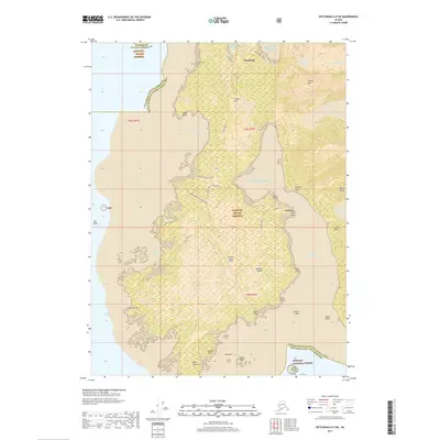
2017 Map of Ketchikan A-5 SW
USGS Topo · Published 2017About this map
Metlakatla sits on the northern edge of this territory within the Annette Island Reserve, serving as the primary hub of settlement on the island. The landscape is defined by its maritime orientation, where the deep waters of Tamgas Harbor and Clarence Strait meet a coastline marked by prominent features like Point Davison and Sextant Point. This maritime infrastructure is anchored by the Annette Island Airport, which occupies a significant portion of the island's interior flatland. Away from the coastal settlements, the terrain rises into the heights of Purple Mtn and Doe Mtn, part of the sprawling Tongass National Forest. For those tracing local history, the Metlakatla Cem and the complex network of local roads like Smuggler's Cove Road and Tamgas Road provide a detailed look at the island's community development and transportation patterns during the late 20th century.
Find a feature on this map
54 named features on this map. Tap any name to fly to it.
Don’t see what you’re looking for? This feature index may not catch every label — zoom into the map to look around manually.
Map Details
Editions of this 2017 Ketchikan A-5 SW Map
This is the sole edition of this map. No revisions or reprints were ever made.
Other maps of this area

1948 · Prince Rupert D-6
USGS Topo · 1:63,360

1948 · Ketchikan A-6
USGS Topo · 1:63,360

1951 · Prince Rupert
USGS Topo · 1:250,000

1951 · Prince Rupert D-6
USGS Topo · 1:63,360

1952 · Ketchikan
USGS Topo · 1:250,000

1955 · Ketchikan A-5
USGS Topo · 1:63,360
1955 · Prince Rupert D-5
USGS Topo · 1:63,360

1955 · Ketchikan
USGS Topo · 1:250,000

1959 · Prince Rupert
USGS Topo · 1:250,000

1964 · Prince Rupert
USGS Topo · 1:250,000