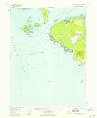
1955 Map of Prince Rupert D-5
USGS Topo · Published 1959About this map
Duke Island dominates this mid-century maritime survey, situated at the confluence of the Clarence Strait and Felice Strait. The interior of the island is marked by the prominent height of Mount Lazaro, while its northern coast shows a cluster of Cabins near Riquette Harbor. These small structures indicate the localized activity within the Tongass National Forest during the 1950s.
Find a feature on this map
40 named features on this map. Tap any name to fly to it.
Don’t see what you’re looking for? This feature index may not catch every label — zoom into the map to look around manually.
Map Details
Editions of this 1955 Prince Rupert D-5 Map
2 editions found
Other maps of this area

1948 · Prince Rupert D-6
USGS Topo · 1:63,360

1948 · Ketchikan A-6
USGS Topo · 1:63,360

1951 · Prince Rupert
USGS Topo · 1:250,000

1951 · Prince Rupert D-6
USGS Topo · 1:63,360

1952 · Ketchikan
USGS Topo · 1:250,000

1955 · Ketchikan A-4
USGS Topo · 1:63,360

1955 · Ketchikan A-5
USGS Topo · 1:63,360
1955 · Prince Rupert D-4
USGS Topo · 1:63,360

1955 · Ketchikan
USGS Topo · 1:250,000

1959 · Prince Rupert
USGS Topo · 1:250,000