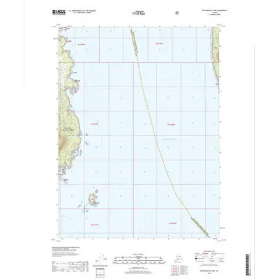
2017 Map of Ketchikan A-6 NW
USGS Topo · Published 2017About this map
Tongass National Forest dominates the western coastline of this marine-focused survey, where the terrestrial wilderness of Southeast Alaska meets the open water of the Gulf of Alaska. The landscape is characterized by intricate coastal features such as Halibut Cr and the prominent Windy Point. To the south, the Wedge Islands sit isolated near the entrance to Port Johnson, serving as critical navigational landmarks in an area defined by its maritime boundaries. The map clearly delineates the administrative line between the Ketchikan Gateway Borough and the Prince of Wales-Hyder Census Area, a boundary that runs through the open water, highlighting the complex jurisdictional nature of these remote coastal waterways.
Find a feature on this map
13 named features on this map. Tap any name to fly to it.
Don’t see what you’re looking for? This feature index may not catch every label — zoom into the map to look around manually.
Map Details
Editions of this 2017 Ketchikan A-6 NW Map
This is the sole edition of this map. No revisions or reprints were ever made.
Other maps of this area

1948 · Ketchikan A-6
USGS Topo · 1:63,360

1948 · Craig A-1
USGS Topo · 1:63,360

1949 · Craig B-1
USGS Topo · 1:63,360

1950 · Craig B-1
USGS Topo · 1:63,360

1952 · Ketchikan
USGS Topo · 1:250,000

1953 · Ketchikan B-6
USGS Topo · 1:63,360

1954 · Ketchikan B-6
USGS Topo · 1:63,360

1955 · Ketchikan
USGS Topo · 1:250,000

1957 · Craig
USGS Topo · 1:250,000
1991 · Ketchikan B-6 SE
USGS Topo · 1:25,000