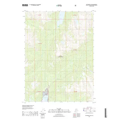
2018 Map of Ketchikan B-2 NW
USGS Topo · Published 2018About this map
Tongass National Forest dominates this coastal Alaska landscape, where steep maritime drainages meet the Pacific Ocean. This survey captures the topographical transition from high alpine basins down to the river valleys that feed into the sea. The Wilson Lake basin serves as a major headwater source, with the Wilson River and Blossom River carving deep paths through the forest towards the coast. Unlike more developed regions, human presence here is primarily indicated by the Quartz Hill Access road, reflecting the area's history of mineral exploration and industrial access within the federal forest lands. The map detail highlights the complex shoreline and the remote nature of the Ketchikan Gateway Borough's wilderness areas.
Find a feature on this map
12 named features on this map. Tap any name to fly to it.
Don’t see what you’re looking for? This feature index may not catch every label — zoom into the map to look around manually.
Map Details
Editions of this 2018 Ketchikan B-2 NW Map
This is the sole edition of this map. No revisions or reprints were ever made.
Other maps of this area

1952 · Ketchikan
USGS Topo · 1:250,000

1955 · Ketchikan C-3
USGS Topo · 1:63,360

1955 · Ketchikan C-2
USGS Topo · 1:63,360

1955 · Ketchikan B-2
USGS Topo · 1:63,360

1955 · Ketchikan B-3
USGS Topo · 1:63,360

1955 · Ketchikan
USGS Topo · 1:250,000

1996 · Ketchikan C-2
USGS Topo · 1:63,360
1996 · Ketchikan C-3
USGS Topo · 1:63,360
2018 · Ketchikan B-3 NE
USGS Topo · 1:25,000
2018 · Ketchikan B-2 NE
USGS Topo · 1:25,000