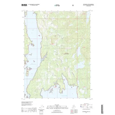
2017 Map of Ketchikan B-4 NW
USGS Topo · Published 2017About this map
Tongass National Forest dominates this coastal Alaska landscape, where the intricate shoreline of the Gulf of Alaska meets the steep, timbered ridges of the Alexander Archipelago. The map reveals a specialized maritime infrastructure, notably the Shoal Cove Field Station and Loran Station-II, reflecting the area's role in navigation and remote research. Waters like Carroll Inlet and Shoal Cove are punctuated by landforms such as Island Point and Osten Island, while the inland terrain rises toward Painted Peak and the twin summits of Heart Hill N and Heart Hill S. The presence of the Gokachin Trail near Granite Lake suggests traditional foot travel through the dense forest, connecting the marine environment of Coho Cove to a series of interior freshwater bodies including Big Lake and Mirror Lake.
Find a feature on this map
45 named features on this map. Tap any name to fly to it.
Don’t see what you’re looking for? This feature index may not catch every label — zoom into the map to look around manually.
Map Details
Editions of this 2017 Ketchikan B-4 NW Map
This is the sole edition of this map. No revisions or reprints were ever made.
Other maps of this area

1948 · Ketchikan C-5
USGS Topo · 1:63,360

1949 · Ketchikan B-4
USGS Topo · 1:63,360

1952 · Ketchikan
USGS Topo · 1:250,000

1952 · Ketchikan B-4
USGS Topo · 1:63,360

1952 · Ketchikan C-4
USGS Topo · 1:63,360

1953 · Ketchikan C-5
USGS Topo · 1:63,360

1954 · Ketchikan B-5
USGS Topo · 1:63,360

1955 · Ketchikan C-4
USGS Topo · 1:63,360

1955 · Ketchikan
USGS Topo · 1:250,000

1955 · Ketchikan B-5
USGS Topo · 1:63,360