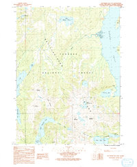
1991 Map of Ketchikan B-5 NW
USGS Topo · Published 1991About this map
Revillagigedo Island presents a landscape defined by its deep freshwater lakes and high peaks within the Tongass National Forest. This 1991 provisional survey highlights the hydrologic system feeding into George Inlet, where glacial and rainwater runoff flows through Ketchikan Creek and Beaver Falls Creek. The terrain is marked by named summits like Dude Mountain and Brown Mountain, which overlook a network of lakes including Harriet Hunt Lake and Lake Emery Tobin. The presence of the Mahoney Mine near Mahoney Lake indicates the industrial history of the region, while the Boardwalk near Perseverance Lake suggests localized infrastructure for traversing the saturated terrain. This map serves as a detailed record of the island's interior before modern developments, tracing the exact positions of high-altitude water bodies like Upper Silvis Lake and Lower Silvis Lake.
Find a feature on this map
31 named features on this map. Tap any name to fly to it.
Don’t see what you’re looking for? This feature index may not catch every label — zoom into the map to look around manually.
Map Details
Editions of this 1991 Ketchikan B-5 NW Map
This is the sole edition of this map. No revisions or reprints were ever made.
Other maps of this area

1948 · Ketchikan C-5
USGS Topo · 1:63,360

1949 · Ketchikan C-6
USGS Topo · 1:63,360

1952 · Ketchikan
USGS Topo · 1:250,000

1952 · Ketchikan C-6
USGS Topo · 1:63,360

1953 · Ketchikan C-5
USGS Topo · 1:63,360

1953 · Ketchikan B-6
USGS Topo · 1:63,360

1954 · Ketchikan B-5
USGS Topo · 1:63,360

1954 · Ketchikan B-6
USGS Topo · 1:63,360

1955 · Ketchikan
USGS Topo · 1:250,000

1955 · Ketchikan B-5
USGS Topo · 1:63,360