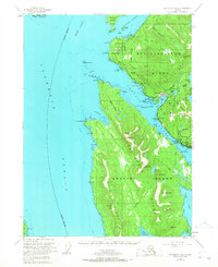
1954 Map of Ketchikan B-6
USGS Topo · Published 1968About this map
Revillagigedo Island and Gravina Island dominate this coastal survey, separated by the vital maritime corridor of Tongass Narrows. The landscape is defined by the industrial and maritime infrastructure of Ketchikan, where a cannery, seaplane base, and multiple radio towers reflect the area's mid-century role as a logistical hub. Development follows the shoreline along North Tongass Road, passing the Ketchikan Rifle Range and Totem Lodge. To the north, the U.S. Coast Guard Station at Pt Higgins monitors the entrance to Behm Canal. The interior remains largely untouched within the Tongass National Forest, though several dams at Connell Lake and Carlanna Lake indicate early water management and power efforts. Evidence of shifting settlement patterns is visible at the abandoned village site near Peninsula Pt.
Find a feature on this map
83 named features on this map. Tap any name to fly to it.
Don’t see what you’re looking for? This feature index may not catch every label — zoom into the map to look around manually.
Map Details
Editions of this 1954 Ketchikan B-6 Map
4 editions found

Other maps of this area

1948 · Ketchikan A-6
USGS Topo · 1:63,360

1948 · Craig A-1
USGS Topo · 1:63,360

1948 · Ketchikan C-5
USGS Topo · 1:63,360

1949 · Ketchikan C-6
USGS Topo · 1:63,360

1949 · Craig B-1
USGS Topo · 1:63,360

1950 · Craig B-1
USGS Topo · 1:63,360

1950 · Craig C-1
USGS Topo · 1:63,360

1951 · Craig C-1
USGS Topo · 1:63,360

1952 · Ketchikan
USGS Topo · 1:250,000

1952 · Ketchikan C-6
USGS Topo · 1:63,360