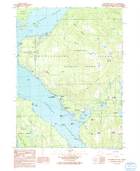
1991 Map of Ketchikan B-6 NE
USGS Topo · Published 1991About this map
Revillagigedo Island serves as the central landmass of this coastal survey, where the maritime and industrial heritage of the Ketchikan region is clearly visible. The western shore along Tongass Narrows and Clover Passage is anchored by the U S Coast Guard Station and the Ward Cannery, reflecting the area's deep ties to navigation and the salmon industry. Cultural preservation is highlighted at the Totem Bight State Historical Park, while the inland topography is defined by the steep rises of Signal Mountain and Ward Mountain. The map details the transition from industrial sites like the Pulp Mill Settling Pond to protected wilderness within the Tongass National Forest, illustrating the managed landscape of Southeast Alaska in the early 1990s.
Find a feature on this map
54 named features on this map. Tap any name to fly to it.
Don’t see what you’re looking for? This feature index may not catch every label — zoom into the map to look around manually.
Map Details
Editions of this 1991 Ketchikan B-6 NE Map
This is the sole edition of this map. No revisions or reprints were ever made.
Other maps of this area

1948 · Ketchikan C-5
USGS Topo · 1:63,360

1949 · Ketchikan C-6
USGS Topo · 1:63,360

1952 · Ketchikan
USGS Topo · 1:250,000

1952 · Ketchikan C-6
USGS Topo · 1:63,360

1953 · Ketchikan C-5
USGS Topo · 1:63,360

1953 · Ketchikan B-6
USGS Topo · 1:63,360

1954 · Ketchikan B-5
USGS Topo · 1:63,360

1954 · Ketchikan B-6
USGS Topo · 1:63,360

1955 · Ketchikan
USGS Topo · 1:250,000

1955 · Ketchikan B-5
USGS Topo · 1:63,360