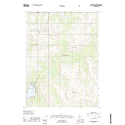
2018 Map of Ketchikan C-2 NW
USGS Topo · Published 2018About this map
The Tongass National Forest dominates this coastal landscape, where high ridgelines and steep drainage basins descend toward the Pacific Ocean. This survey captures the intricate topography of the Ketchikan Gateway Borough, characterized by significant elevation changes that feed into Walker Lake and its outlet, Walker Cr, in the northern portion of the quadrangle. The southwestern corner of the sheet reveals the saltwater transition at Rudyard Bay, a deep glacial fjord carving into the mainland. The absence of roads or permanent structures reflects the primitive state of this wilderness area within the national forest system, emphasizing a landscape defined by natural boundaries and hydrographic features rather than human development.
Find a feature on this map
10 named features on this map. Tap any name to fly to it.
Don’t see what you’re looking for? This feature index may not catch every label — zoom into the map to look around manually.
Map Details
Editions of this 2018 Ketchikan C-2 NW Map
This is the sole edition of this map. No revisions or reprints were ever made.
Other maps of this area

1952 · Ketchikan
USGS Topo · 1:250,000

1955 · Ketchikan C-3
USGS Topo · 1:63,360

1955 · Ketchikan D-2
USGS Topo · 1:63,360

1955 · Ketchikan C-2
USGS Topo · 1:63,360

1955 · Ketchikan D-3
USGS Topo · 1:63,360

1955 · Ketchikan
USGS Topo · 1:250,000

1996 · Ketchikan C-2
USGS Topo · 1:63,360
1996 · Ketchikan D-3
USGS Topo · 1:63,360
1996 · Ketchikan D-2
USGS Topo · 1:63,360
1996 · Ketchikan C-3
USGS Topo · 1:63,360