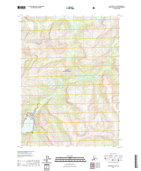
2021 Map of Ketchikan C-2 NW
USGS Topo · Published 2021About this map
Tongass National Forest covers this coastal Alaskan terrain, where high peaks and deep glacial drainages meet the sea. The landscape is defined by the steep rises of the Adam Mountains and the winding course of Walker Cr, which feeds into the secluded waters of Walker Lake. Along the southwestern edge of the quadrangle, the saltwater reaches of Rudyard Bay cut into the coastline, highlighting the dramatic transition from subalpine heights to tidal inlets. This 2021 survey by the U.S. Geological Survey preserves the topographical details of a wilderness shaped by heavy precipitation and extreme relief, capturing the precise drainage patterns and forest boundaries within the Ketchikan Gateway Borough.
Find a feature on this map
11 named features on this map. Tap any name to fly to it.
Don’t see what you’re looking for? This feature index may not catch every label — zoom into the map to look around manually.
Map Details
Editions of this 2021 Ketchikan C-2 NW Map
This is the sole edition of this map. No revisions or reprints were ever made.
Other maps of this area

1952 · Ketchikan
USGS Topo · 1:250,000

1955 · Ketchikan C-3
USGS Topo · 1:63,360

1955 · Ketchikan D-2
USGS Topo · 1:63,360

1955 · Ketchikan C-2
USGS Topo · 1:63,360

1955 · Ketchikan D-3
USGS Topo · 1:63,360

1955 · Ketchikan
USGS Topo · 1:250,000

1996 · Ketchikan C-2
USGS Topo · 1:63,360
1996 · Ketchikan D-3
USGS Topo · 1:63,360
1996 · Ketchikan D-2
USGS Topo · 1:63,360
1996 · Ketchikan C-3
USGS Topo · 1:63,360