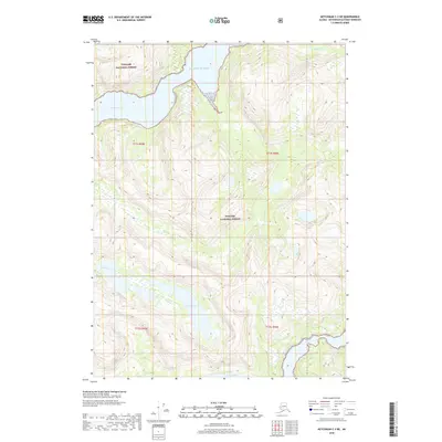
2018 Map of Ketchikan C-3 NE
USGS Topo · Published 2018About this map
Tongass National Forest dominates this coastal landscape, where the tides of the Pacific Ocean reach deep into the interior via Walker Cove. The 2018 survey reveals a terrain defined by dramatic elevation changes and significant freshwater bodies, most notably the elongated Lake Manzoni and the southern Nooya Lake. These glaciated valleys are fed by drainages such as Walker Cr in the north and Granite Creek in the west, illustrating the intricate hydrology of the Ketchikan Gateway region. The map preserves the exact township and range boundaries, including t71s r95e and t72s r96e, providing a precise spatial framework for land management and ecological study in this maritime wilderness.
Find a feature on this map
11 named features on this map. Tap any name to fly to it.
Don’t see what you’re looking for? This feature index may not catch every label — zoom into the map to look around manually.
Map Details
Editions of this 2018 Ketchikan C-3 NE Map
This is the sole edition of this map. No revisions or reprints were ever made.
Other maps of this area

1952 · Ketchikan
USGS Topo · 1:250,000

1955 · Ketchikan C-3
USGS Topo · 1:63,360

1955 · Ketchikan D-2
USGS Topo · 1:63,360

1955 · Ketchikan C-2
USGS Topo · 1:63,360

1955 · Ketchikan D-3
USGS Topo · 1:63,360

1955 · Ketchikan
USGS Topo · 1:250,000

1996 · Ketchikan C-2
USGS Topo · 1:63,360
1996 · Ketchikan D-3
USGS Topo · 1:63,360
1996 · Ketchikan D-2
USGS Topo · 1:63,360
1996 · Ketchikan C-3
USGS Topo · 1:63,360