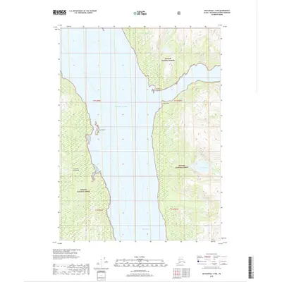
2018 Map of Ketchikan C-3 NW
USGS Topo · Published 2018About this map
Tongass National Forest dominates the coastal landscape of this portion of the Alexander Archipelago, where steep-sided fjords and waterways define the geography. The deep waters of Behm Canal and the Pacific Ocean separate the landmasses, creating a complex maritime environment typical of Southeast Alaska. Navigation points such as Hut Point and Ledge Point mark the transition from open water into narrower inlets. On the western shore, Grace Cove provides a sheltered break in the coastline, fed by the waters of Grace Cr. Across the canal, the eastern terrain is carved by Granite Creek, which flows through heavily contoured elevations. This 2018 survey illustrates the primitive state of this wilderness area, showing a complete absence of developed roads or settlements, with the Snip Islands standing as small outposts in the central channel.
Find a feature on this map
15 named features on this map. Tap any name to fly to it.
Don’t see what you’re looking for? This feature index may not catch every label — zoom into the map to look around manually.
Map Details
Editions of this 2018 Ketchikan C-3 NW Map
This is the sole edition of this map. No revisions or reprints were ever made.
Other maps of this area

1952 · Ketchikan
USGS Topo · 1:250,000

1952 · Ketchikan C-4
USGS Topo · 1:63,360

1955 · Ketchikan C-3
USGS Topo · 1:63,360

1955 · Ketchikan D-4
USGS Topo · 1:63,360

1955 · Ketchikan D-3
USGS Topo · 1:63,360

1955 · Ketchikan C-4
USGS Topo · 1:63,360

1955 · Ketchikan
USGS Topo · 1:250,000
1962 · Ketchikan D-4
USGS Topo · 1:63,360
1995 · Ketchikan C-4
USGS Topo · 1:63,360
1996 · Ketchikan D-4
USGS Topo · 1:63,360