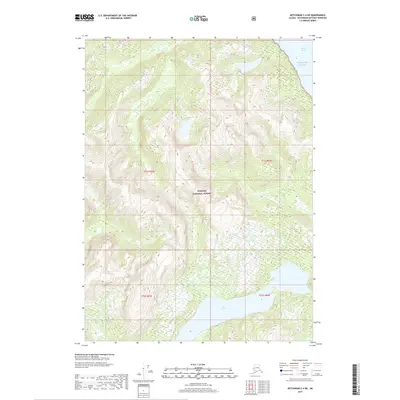
2017 Map of Ketchikan C-4 NE
USGS Topo · Published 2017About this map
Tongass National Forest dominates this coastal landscape, where the mountainous terrain of the Alexander Archipelago meets the Gulf of Alaska. The interior of the quadrangle is defined by steep glacial topography and substantial inland water bodies, most notably Lake Grace, which stretches across the southern sections. Along the eastern edge, the waters of the Behm Canal provide a deep-water passage through the coastal fjords, fed by smaller drainages such as Fromholz Cr. This 2017 survey reflects a wilderness environment managed for conservation and natural resources, showing the intricate relationship between the high coastal peaks and the marine environment of Southeast Alaska. The map detail is focused on hydrography and elevation, capturing the primary natural landmarks that define this portion of the Ketchikan Gateway Borough.
Find a feature on this map
9 named features on this map. Tap any name to fly to it.
Don’t see what you’re looking for? This feature index may not catch every label — zoom into the map to look around manually.
Map Details
Editions of this 2017 Ketchikan C-4 NE Map
This is the sole edition of this map. No revisions or reprints were ever made.
Other maps of this area

1952 · Ketchikan
USGS Topo · 1:250,000

1952 · Ketchikan C-4
USGS Topo · 1:63,360

1955 · Ketchikan C-3
USGS Topo · 1:63,360

1955 · Ketchikan D-4
USGS Topo · 1:63,360

1955 · Ketchikan D-3
USGS Topo · 1:63,360

1955 · Ketchikan C-4
USGS Topo · 1:63,360

1955 · Ketchikan
USGS Topo · 1:250,000
1962 · Ketchikan D-4
USGS Topo · 1:63,360
1995 · Ketchikan C-4
USGS Topo · 1:63,360
1996 · Ketchikan D-4
USGS Topo · 1:63,360