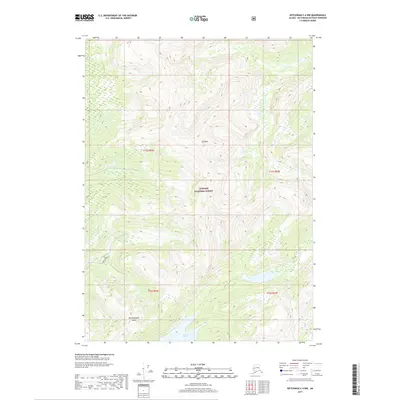
2017 Map of Ketchikan C-4 NW
USGS Topo · Published 2017About this map
Revillagigedo Island presents a landscape shaped by elevation and glacial legacy in this recent topographic study. The area is dominated by the Tongass National Forest, showing a terrain where deep ravines and steep slopes rise toward the summit of Mt Reid. The drainage patterns are clearly defined, with Falls Cr cutting through the central interior before descending toward the southern shoreline. On the southern edge of the sheet, the waters of Swan Lake mark a rare level basin amidst the surrounding peaks. This 2017 survey documents the undeveloped character of the Alaska panhandle's interior, providing precise elevation data for navigators and environmental researchers within one of the nation's largest protected forest reserves.
Find a feature on this map
9 named features on this map. Tap any name to fly to it.
Don’t see what you’re looking for? This feature index may not catch every label — zoom into the map to look around manually.
Map Details
Editions of this 2017 Ketchikan C-4 NW Map
This is the sole edition of this map. No revisions or reprints were ever made.
Other maps of this area

1948 · Ketchikan C-5
USGS Topo · 1:63,360

1952 · Ketchikan
USGS Topo · 1:250,000

1952 · Ketchikan C-4
USGS Topo · 1:63,360

1952 · Ketchikan D-5
USGS Topo · 1:63,360

1953 · Ketchikan C-5
USGS Topo · 1:63,360

1953 · Ketchikan D-5
USGS Topo · 1:63,360

1955 · Ketchikan D-4
USGS Topo · 1:63,360

1955 · Ketchikan C-4
USGS Topo · 1:63,360

1955 · Ketchikan
USGS Topo · 1:250,000
1962 · Ketchikan D-4
USGS Topo · 1:63,360