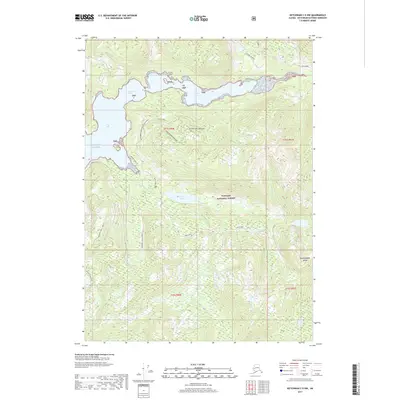
2017 Map of Ketchikan C-5 NW
USGS Topo · Published 2017About this map
Revillagigedo Island presents a complex network of coastal inlets and managed forest lands within the Tongass National Forest as of 2017. The coastline is defined by the deep reach of Traitors Cove and the northern waters of Behm Canal, where Indian Point marks a prominent landform at the edge of the Gulf of Alaska. Inland, the landscape centers on Margaret Lake and its associated drainage systems, including Margaret Creek S Fork W and Margaret Creek S Fork E. The 2017 infrastructure reveals the footprint of timber management and forest access, specifically the 8000000 Margaret Road System and its numerous branches like 8000500 Road Margaret and the Firebug spurs. This era of mapping shows a landscape primarily utilized for natural resource management and conservation, with no permanent settlements but significant naming of specific hydrological features like Francis Cove Creek and Traitors Creek.
Find a feature on this map
23 named features on this map. Tap any name to fly to it.
Don’t see what you’re looking for? This feature index may not catch every label — zoom into the map to look around manually.
Map Details
Editions of this 2017 Ketchikan C-5 NW Map
This is the sole edition of this map. No revisions or reprints were ever made.
Other maps of this area

1948 · Ketchikan C-5
USGS Topo · 1:63,360

1949 · Ketchikan C-6
USGS Topo · 1:63,360

1952 · Ketchikan
USGS Topo · 1:250,000

1952 · Ketchikan C-6
USGS Topo · 1:63,360

1952 · Ketchikan D-5
USGS Topo · 1:63,360

1952 · Ketchikan D-6
USGS Topo · 1:63,360

1953 · Ketchikan C-5
USGS Topo · 1:63,360

1953 · Ketchikan D-5
USGS Topo · 1:63,360

1953 · Ketchikan D-6
USGS Topo · 1:63,360

1955 · Ketchikan
USGS Topo · 1:250,000