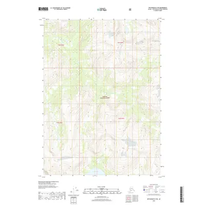
2018 Map of Ketchikan D-2 SW
USGS Topo · Published 2018About this map
Tongass National Forest encompasses the entirety of this coastal Alaska landscape, dominated by significant elevation changes and glacial-fed drainage systems. The S Fork Chickamin River flows through the northwestern portion of the map, while the southern boundary is defined by the presence of Walker Lake. This 2018 survey illustrates the primitive hydrography of the region, including smaller tributaries like Barrier Cr that navigate the steep terrain. The map serves as a primary record of public land divisions, specifically detailing the intersection of townships t69s r96e, t69s r97e, t70s r96e, and t70s r97e. This is a landscape defined by its lack of human infrastructure, focusing instead on the natural topography and waterway network within the national forest system.
Find a feature on this map
8 named features on this map. Tap any name to fly to it.
Don’t see what you’re looking for? This feature index may not catch every label — zoom into the map to look around manually.
Map Details
Editions of this 2018 Ketchikan D-2 SW Map
This is the sole edition of this map. No revisions or reprints were ever made.
Other maps of this area

1952 · Ketchikan
USGS Topo · 1:250,000

1955 · Ketchikan C-3
USGS Topo · 1:63,360

1955 · Ketchikan D-2
USGS Topo · 1:63,360

1955 · Ketchikan C-2
USGS Topo · 1:63,360

1955 · Ketchikan D-3
USGS Topo · 1:63,360

1955 · Ketchikan
USGS Topo · 1:250,000

1996 · Ketchikan C-2
USGS Topo · 1:63,360
1996 · Ketchikan D-3
USGS Topo · 1:63,360
1996 · Ketchikan D-2
USGS Topo · 1:63,360
1996 · Ketchikan C-3
USGS Topo · 1:63,360