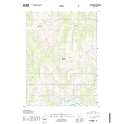
2018 Map of Ketchikan D-3 SE
USGS Topo · Published 2018About this map
Tongass National Forest covers the majority of this coastal Alaskan landscape, where steep mountainous terrain meets the saltwater of Walker Cove. This 2018 survey captures a purely natural environment defined by high-elevation ridges and a network of glacial and snowmelt drainage systems. Water features dominate the geography, from the S Fork Chickamin River in the northeast to the interior Gilbert Lake. Significant drainages including King Cr and Choca Cr carve through the deep valleys of the coastal range before reaching the Pacific Ocean. The map provides a detailed view of these untouched waterways and the complex contours of the Tongass wilderness, illustrating the hydrological patterns of the Ketchikan Gateway region without any mapped human infrastructure or permanent settlements.
Find a feature on this map
12 named features on this map. Tap any name to fly to it.
Don’t see what you’re looking for? This feature index may not catch every label — zoom into the map to look around manually.
Map Details
Editions of this 2018 Ketchikan D-3 SE Map
This is the sole edition of this map. No revisions or reprints were ever made.
Other maps of this area

1952 · Ketchikan
USGS Topo · 1:250,000

1955 · Ketchikan C-3
USGS Topo · 1:63,360

1955 · Ketchikan D-2
USGS Topo · 1:63,360

1955 · Ketchikan C-2
USGS Topo · 1:63,360

1955 · Ketchikan D-3
USGS Topo · 1:63,360

1955 · Ketchikan
USGS Topo · 1:250,000

1996 · Ketchikan C-2
USGS Topo · 1:63,360
1996 · Ketchikan D-3
USGS Topo · 1:63,360
1996 · Ketchikan D-2
USGS Topo · 1:63,360
1996 · Ketchikan C-3
USGS Topo · 1:63,360