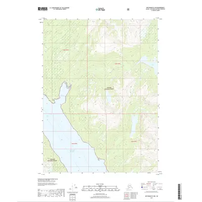
2017 Map of Ketchikan D-4 NE
USGS Topo · Published 2017About this map
Tongass National Forest dominates this landscape in the Ketchikan Gateway Borough, where steep coastal elevations meet the tidal waters of the Gulf of Alaska. The topography is defined by the narrow passage of Behm Canal, which carves into the shoreline near Fire Point. Inland, the drainage network is anchored by Saks Lake, which feeds Saks Cr as it descends toward the saltwater. To the south, Robinson Cr cuts through the heavy timber and high ridges characteristic of Southeast Alaska. This 2017 survey illustrates the complex relationship between the rainforest and the sea, showing how Saks Cove provides a natural indentation in a coastline otherwise marked by dramatic vertical rises and glacial-carved drainages.
Find a feature on this map
12 named features on this map. Tap any name to fly to it.
Don’t see what you’re looking for? This feature index may not catch every label — zoom into the map to look around manually.
Map Details
Editions of this 2017 Ketchikan D-4 NE Map
This is the sole edition of this map. No revisions or reprints were ever made.
Other maps of this area

1951 · Bradfield Canal
USGS Topo · 1:250,000

1952 · Ketchikan
USGS Topo · 1:250,000

1954 · Bradfield Canal
USGS Topo · 1:250,000

1955 · Bradfield canal A-4
USGS Topo · 1:63,360

1955 · Ketchikan D-4
USGS Topo · 1:63,360

1955 · Ketchikan D-3
USGS Topo · 1:63,360

1955 · Bradfield canal A-3
USGS Topo · 1:63,360

1955 · Ketchikan
USGS Topo · 1:250,000

1955 · Bradfield Canal
USGS Topo · 1:250,000
1962 · Ketchikan D-4
USGS Topo · 1:63,360