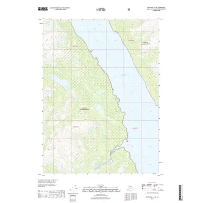
2017 Map of Ketchikan D-4 SE
USGS Topo · Published 2017About this map
Behm Canal defines this coastal stretch of Southeast Alaska, where steep forested slopes drop directly into the deep waters of the Gulf of Alaska. This 2017 topographic study highlights the primitive landscape within the Tongass National Forest, characterized by complex hydrology and shoreline indentations like Portage Cove. The absence of roads or permanent settlements emphasizes the region's reliance on maritime navigation and the preservation of its natural state. Surveyed late in the twentieth century and updated with modern imagery, the map details the rugged verticality of the Ketchikan Gateway Borough, revealing the dense network of streams and wetlands that drain the coastal mountains into the canal.
Find a feature on this map
9 named features on this map. Tap any name to fly to it.
Don’t see what you’re looking for? This feature index may not catch every label — zoom into the map to look around manually.
Map Details
Editions of this 2017 Ketchikan D-4 SE Map
This is the sole edition of this map. No revisions or reprints were ever made.
Other maps of this area

1952 · Ketchikan
USGS Topo · 1:250,000

1952 · Ketchikan C-4
USGS Topo · 1:63,360

1955 · Ketchikan C-3
USGS Topo · 1:63,360

1955 · Ketchikan D-4
USGS Topo · 1:63,360

1955 · Ketchikan D-3
USGS Topo · 1:63,360

1955 · Ketchikan C-4
USGS Topo · 1:63,360

1955 · Ketchikan
USGS Topo · 1:250,000
1962 · Ketchikan D-4
USGS Topo · 1:63,360
1995 · Ketchikan C-4
USGS Topo · 1:63,360
1996 · Ketchikan D-4
USGS Topo · 1:63,360