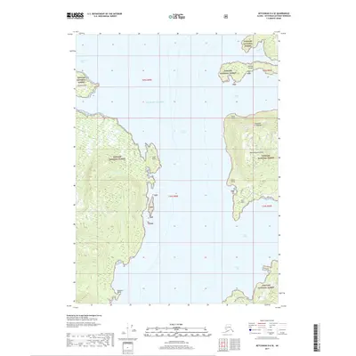
2017 Map of Ketchikan D-6 SE
USGS Topo · Published 2017About this map
The Alexander Archipelago characterizes this coastal Alaskan landscape, where the waters of the Gulf of Alaska meet the rugged inlets of the Tongass National Forest. Dominated by the landmasses of Revillagigedo Island and several smaller islands like Gedney Island and Square Island, the area is defined by its dramatic maritime geography. Deep water features such as Behm Canal and Neets Bay separate the timbered shorelines, which are punctuated by distinctive landmarks like Nose Point, Snail Point, and Chin Point. Inland, the forest is marked by the presence of numerous TNF administrative points, indicating the federal management of these remote coastal reaches. Near the southern edge of the survey, the Bushy 8060500 Road represents a rare instance of terrestrial infrastructure in a region primarily accessible by sea via routes like Gedney Pass or Spacious Bay.
Find a feature on this map
22 named features on this map. Tap any name to fly to it.
Don’t see what you’re looking for? This feature index may not catch every label — zoom into the map to look around manually.
Map Details
Editions of this 2017 Ketchikan D-6 SE Map
This is the sole edition of this map. No revisions or reprints were ever made.
Other maps of this area

1948 · Ketchikan C-5
USGS Topo · 1:63,360

1949 · Ketchikan C-6
USGS Topo · 1:63,360

1952 · Ketchikan
USGS Topo · 1:250,000

1952 · Ketchikan C-6
USGS Topo · 1:63,360

1952 · Ketchikan D-5
USGS Topo · 1:63,360

1952 · Ketchikan D-6
USGS Topo · 1:63,360

1953 · Ketchikan C-5
USGS Topo · 1:63,360

1953 · Ketchikan D-5
USGS Topo · 1:63,360

1953 · Ketchikan D-6
USGS Topo · 1:63,360

1955 · Ketchikan
USGS Topo · 1:250,000