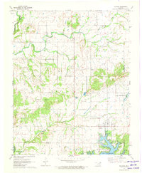
1971 Map of Ketchum
USGS Topo · Published 1973About this map
The waters of Lake O' The Cherokees define the southeastern corner of this landscape, where the town of Ketchum sits adjacent to the sprawling reservoir. This early 1970s survey documents a region transitioning toward recreation and infrastructure, evidenced by the development of Grand Lake Towne and the utility of the Vinita Waterworks. To the southwest, the headwaters of Lake Hudson begin to form along the Big Cabin Creek drainage. Local history is preserved in the location of the Old Ketchum Cem and Carselowey Cem, while rural life is anchored by the Foursquare Gospel Ch. The map also traces the legacy of former transportation routes through an Old Railroad Grade and specialized land use such as the Fish Hatchery and several quarries.
Find a feature on this map
37 named features on this map. Tap any name to fly to it.
Don’t see what you’re looking for? This feature index may not catch every label — zoom into the map to look around manually.
Map Details
Editions of this 1971 Ketchum Map
This is the sole edition of this map. No revisions or reprints were ever made.
Other maps of this area

1896 · Pryor
USGS Topo · 1:125,000

1899 · Siloam Springs
USGS Topo · 1:125,000

1901 · Vinita
USGS Topo · 1:125,000

1901 · Pryor
USGS Topo · 1:125,000

1903 · Siloam Springs
USGS Topo · 1:125,000

1904 · Siloam Springs
USGS Topo · 1:125,000

1907 · Wyandotte
USGS Topo · 1:125,000

1909 · Wyandotte
USGS Topo · 1:125,000

1913 · Vinita
USGS Topo · 1:125,000

1954 · Tulsa
USGS Topo · 1:250,000