1994 Map of Ketchum Reservoir
USGS Topo · Published 1997About this map
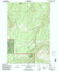
Fir Mountain and the complex drainage systems of the eastern Cascades define this landscape on the border of Hood River and Wasco Counties. The topography is shaped by deeply incised canyons and ridges, such as Sheldon Ridge and Honeysuckle Ridge, where numerous seasonal springs and creeks converge. Water management is a primary theme of the area, evidenced by the The Dalles Watershed Management Unit and the Ketchum Reservoir, which sits adjacent to Ketchum Ranch.
Find a feature on this map
41 named features on this map. Tap any name to fly to it.
Don’t see what you’re looking for? This feature index may not catch every label — zoom into the map to look around manually.
Map Details
Editions of this 1994 Ketchum Reservoir Map
This is the sole edition of this map. No revisions or reprints were ever made.
Other maps of this area

1924 · Mount Hood
USGS Topo · 1:125,000

1926 · Hood River
USGS Topo · 1:125,000

1927 · Mount Hood
USGS Topo · 1:125,000

1929 · Hood River
USGS Topo · 1:125,000

1930 · Dufur
USGS Topo · 1:125,000

1934 · Dufur
USGS Topo · 1:125,000

1934 · The Dalles
USGS Topo · 1:125,000

1953 · The Dalles
USGS Topo · 1:250,000

1956 · The Dalles
USGS Topo · 1:250,000

1957 · The Dalles
USGS Topo · 1:250,000