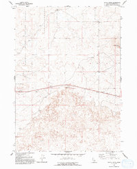
1964 Map of Kettle Butte
USGS Topo · Published 1993About this map
The National Reactor Testing Station occupies the western edge of this mid-1960s survey, marking a period of significant federal scientific investment in the Idaho desert. The landscape is defined by vast volcanic fields, simply labeled as Lava, which dominate the southern half of the quadrangle. High points like Kettle Butte, featuring the Pinhead peak, and the prominent Twentymile Rock serve as the primary landmarks in this otherwise desolate terrain. Human infrastructure is sparse, concentrated primarily along the corridor of State Road 20 and a handful of utility sites like Taylor Well and several Borrow Pit excavations, likely used for road construction or maintenance during the area's development for nuclear research and testing purposes.
Find a feature on this map
8 named features on this map. Tap any name to fly to it.
Don’t see what you’re looking for? This feature index may not catch every label — zoom into the map to look around manually.
Map Details
Editions of this 1964 Kettle Butte Map
2 editions found
Other maps of this area

1955 · Idaho Falls
USGS Topo · 1:250,000

1958 · Idaho Falls
USGS Topo · 1:250,000

1964 · Kettle Butte NE
USGS Topo · 1:24,000

1964 · Kettle Butte NW
USGS Topo · 1:24,000

1964 · Kettle Butte SW
USGS Topo · 1:24,000
1964 · Morgans Pasture NE
USGS Topo · 1:24,000
1964 · Butterfly Butte
USGS Topo · 1:24,000

1973 · Little Butte NE
USGS Topo · 1:24,000

1973 · Little Butte
USGS Topo · 1:24,000

1973 · Taber NE
USGS Topo · 1:24,000