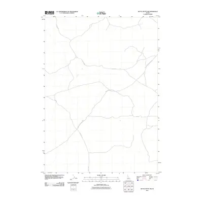
2010 Map of Kettle Butte NW
USGS Topo · Published 2010About this map
The high desert landscape of Twin Butte Sage Junction Rd and the surrounding Idaho plains are captured in this 2010 topographic record. This area is defined by a sparse but essential network of rural roads that navigate the sagebrush-covered terrain. Little Burn Rd and Sheep Rd branch across the quadrangle, indicating the region's agricultural and grazing utility. Further south, the intersection of Mud Lake Rd and E 300 N provides a clear view of the rectilinear surveying and transportation patterns common to this part of the Snake River Plain. The map's contouring reveals the subtle volcanic geology of the region, where the vast, open expanses are punctuated by minimal human development and long-distance ranching routes.
Find a feature on this map
5 named features on this map. Tap any name to fly to it.
Don’t see what you’re looking for? This feature index may not catch every label — zoom into the map to look around manually.
Map Details
Editions of this 2010 Kettle Butte NW Map
This is the sole edition of this map. No revisions or reprints were ever made.
Other maps of this area

1955 · Idaho Falls
USGS Topo · 1:250,000

1958 · Idaho Falls
USGS Topo · 1:250,000

1964 · Kettle Butte NE
USGS Topo · 1:24,000

1964 · Kettle Butte NW
USGS Topo · 1:24,000

1964 · Kettle Butte SW
USGS Topo · 1:24,000

1964 · Terreton
USGS Topo · 1:24,000
1964 · Butterfly Butte
USGS Topo · 1:24,000

1964 · Mud Lake SE
USGS Topo · 1:24,000

1969 · Antelope Butte
USGS Topo · 1:24,000

1973 · Little Butte NE
USGS Topo · 1:24,000