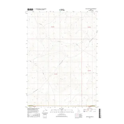
2017 Map of Kettle Butte NW
USGS Topo · Published 2017About this map
Jefferson and Bonneville counties intersect in this volcanic and sagebrush-covered landscape, where the high desert terrain is defined by undulating contours and primitive transit corridors. The remote character of the region is evident in the sparse infrastructure, dominated by long-distance tracks such as Twin Butte Sage Junction Rd and Sheep Rd. These routes trace the natural topography, likely serving as essential conduits for regional livestock movement or access to the high-elevation flats. The northern portion of the map is traversed by Little Burn Rd, while the southern reaches briefly touch the rural grid at E 300 N. The absence of dense settlement and the prominence of the Jefferson Co Bonneville Co boundary reflect a transition zone between managed agricultural lands and the open, high-elevation scrubland of eastern Idaho.
Find a feature on this map
11 named features on this map. Tap any name to fly to it.
Don’t see what you’re looking for? This feature index may not catch every label — zoom into the map to look around manually.
Map Details
Editions of this 2017 Kettle Butte NW Map
This is the sole edition of this map. No revisions or reprints were ever made.
Other maps of this area

1955 · Idaho Falls
USGS Topo · 1:250,000

1958 · Idaho Falls
USGS Topo · 1:250,000

1964 · Kettle Butte NE
USGS Topo · 1:24,000

1964 · Kettle Butte NW
USGS Topo · 1:24,000

1964 · Kettle Butte SW
USGS Topo · 1:24,000

1964 · Terreton
USGS Topo · 1:24,000
1964 · Butterfly Butte
USGS Topo · 1:24,000

1964 · Mud Lake SE
USGS Topo · 1:24,000

1969 · Antelope Butte
USGS Topo · 1:24,000

1973 · Little Butte NE
USGS Topo · 1:24,000