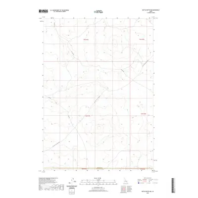
2020 Map of Kettle Butte NW
USGS Topo · Published 2020About this map
High desert plains and the stark boundaries of Jefferson Co and Bonneville Co define this portion of southeastern Idaho. The landscape is marked by a deliberate network of agricultural and access roads, including the diagonal path of Twin Butte Sage Junction Rd and the straight lines of E 300 N. This 2020 survey illustrates the modern configuration of the Snake River Plain, where the township and range system has dictated the layout of the land since early settlement. The geography here is dominated by subtle changes in elevation, with Sheep Rd and Little Burn Rd providing the primary transit routes through these expansive rangelands. This map is essential for researchers looking to pinpoint specific section corners and boundary lines in a region where few natural landmarks exist to orient the traveler.
Find a feature on this map
12 named features on this map. Tap any name to fly to it.
Don’t see what you’re looking for? This feature index may not catch every label — zoom into the map to look around manually.
Map Details
Editions of this 2020 Kettle Butte NW Map
This is the sole edition of this map. No revisions or reprints were ever made.
Other maps of this area

1955 · Idaho Falls
USGS Topo · 1:250,000

1958 · Idaho Falls
USGS Topo · 1:250,000

1964 · Kettle Butte NE
USGS Topo · 1:24,000

1964 · Kettle Butte NW
USGS Topo · 1:24,000

1964 · Kettle Butte SW
USGS Topo · 1:24,000

1964 · Terreton
USGS Topo · 1:24,000
1964 · Butterfly Butte
USGS Topo · 1:24,000

1964 · Mud Lake SE
USGS Topo · 1:24,000

1969 · Antelope Butte
USGS Topo · 1:24,000

1973 · Little Butte NE
USGS Topo · 1:24,000