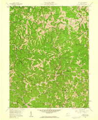
1958 Map of Kettle
USGS Topo · Published 1959About this map
Ambler Ridge and Patton Ridge dominate this central West Virginia landscape, where mid-century life followed the deeply carved hollows and winding creek beds. This 1950s survey captures a rural environment defined by small ridge-top and valley-floor settlements like Kettle and Doddtown. The local economy is visibly centered on the extraction of natural resources, with the Walton Oil Field and Rock Creek Oil Field spanning large portions of the terrain.
Find a feature on this map
91 named features on this map. Tap any name to fly to it.
Don’t see what you’re looking for? This feature index may not catch every label — zoom into the map to look around manually.
Map Details
Editions of this 1958 Kettle Map
3 editions found
Other maps of this area

1897 · Kanawha Falls
USGS Topo · 1:125,000

1899 · Charleston
USGS Topo · 1:125,000

1900 · Kanawha Falls
USGS Topo · 1:125,000

1901 · Kanawha Falls
USGS Topo · 1:125,000

1906 · Kenna
USGS Topo · 1:62,500

1906 · Walton
USGS Topo · 1:62,500

1907 · Kenna
USGS Topo · 1:62,500

1907 · Walton
USGS Topo · 1:62,500

1907 · Clendenin
USGS Topo · 1:62,500

1909 · Charleston
USGS Topo · 1:62,500