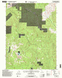
1994 Map of Kettle Rock
USGS Topo · Published 1998About this map
Plumas National Forest dominates this topographic study of the high Sierra Nevada, centered on the prominent granite landmark of Kettle Rock. The landscape is a complex of steep drainages and isolated valleys like Wilcox Valley and Lone Rock Valley, where the presence of the Engel Mine Upper Camp and Lucky S Mine points to the area's history of mineral extraction. Mining infrastructure is visible through marked Tailings and a Quarry in the south, while the timber and range management of the late 20th century is evidenced by the network of primitive roads like the Diamond Mountain Motorway.
Find a feature on this map
43 named features on this map. Tap any name to fly to it.
Don’t see what you’re looking for? This feature index may not catch every label — zoom into the map to look around manually.
Map Details
Editions of this 1994 Kettle Rock Map
2 editions found
Other maps of this area

1886 · Honey Lake
USGS Topo · 1:250,000

1891 · Honey Lake
USGS Topo · 1:250,000

1893 · Honey Lake
USGS Topo · 1:250,000

1950 · Kettle Rock
USGS Topo · 1:62,500

1950 · Greenville
USGS Topo · 1:62,500

1954 · Susanville
USGS Topo · 1:62,500

1955 · Westwood
USGS Topo · 1:62,500

1955 · Westwood
USGS Topo · 1:250,000

1958 · Westwood
USGS Topo · 1:250,000

1959 · Westwood
USGS Topo · 1:250,000