
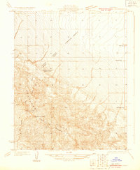
1930 Map of Kettleman Plain
USGS Topo · Published 1930About this map
Kettleman Hills dominate the topography of this survey, defining a period of early twentieth-century petroleum exploration in Kings County. The landscape is marked by industrial infrastructure including multiple Oil Wells, an Oil Prospect, and an Oil Pumping Sta, reflecting the intensive development of the Kettleman North Dome area shortly after its discovery. This industrial activity is centered within the broader Kettleman Plain, flanked by the prominent uplift of Reef Ridge to the west.
Find a feature on this map
10 named features on this map. Tap any name to fly to it.
Don’t see what you’re looking for? This feature index may not catch every label — zoom into the map to look around manually.
Map Details
Editions of this 1930 Kettleman Plain Map
This is the sole edition of this map. No revisions or reprints were ever made.
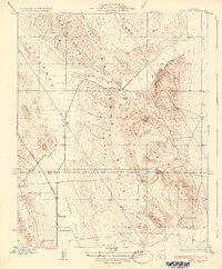
Other maps of this area

1912 · Coalinga
USGS Topo · 1:125,000

1914 · Lost Hills
USGS Topo · 1:125,000

1914 · Cholame
USGS Topo · 1:125,000

1915 · Cholame
USGS Topo · 1:125,000

1917 · Cholame
USGS Topo · 1:125,000
1930 · Discovery Well
USGS Topo · 1:31,680

1930 · Avenal Gap
USGS Topo · 1:31,680

1930 · Canoas Creek
USGS Topo · 1:31,680

1930 · Middle Dome
USGS Topo · 1:31,680
1933 · Avenal Gap
USGS Topo · 1:31,680