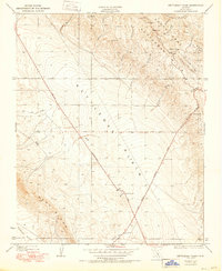
1950 Map of Kettleman Plain
USGS Topo · Published 1950About this map
Kettleman Plain serves as the central trough in this 1950 edition based on 1930 surveys, showing the landscape of the California oil industry before mid-century expansion. The map details the transition from the steep elevations of Reef Ridge and Sunflower Valley in the southwest to the petroleum-bearing heights of the Kettleman Hills in the northeast. This area, particularly the North Dome, is defined by its industrial geography, highlighted by a lone Oil Pumping Sta and the specialized naming of Drillers Ridge and Bullwheel Ridge.
Find a feature on this map
36 named features on this map. Tap any name to fly to it.
Don’t see what you’re looking for? This feature index may not catch every label — zoom into the map to look around manually.
Map Details
Editions of this 1950 Kettleman Plain Map
This is the sole edition of this map. No revisions or reprints were ever made.
Other maps of this area

1912 · Coalinga
USGS Topo · 1:125,000

1914 · Lost Hills
USGS Topo · 1:125,000

1914 · Cholame
USGS Topo · 1:125,000

1915 · Cholame
USGS Topo · 1:125,000

1917 · Cholame
USGS Topo · 1:125,000

1930 · Discovery Well
USGS Topo · 1:31,680

1930 · Avenal Gap
USGS Topo · 1:31,680

1930 · Canoas Creek
USGS Topo · 1:31,680

1930 · Kettleman Plain
USGS Topo · 1:31,680

1930 · Middle Dome
USGS Topo · 1:31,680