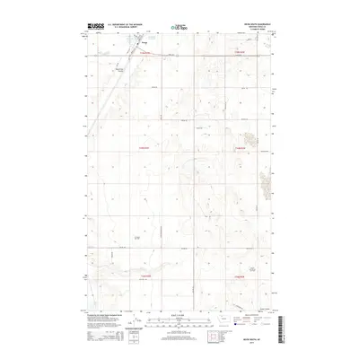
2014 Map of Kevin South
USGS Topo · Published 2014About this map
Kevin stands at the northern edge of this high-plains landscape, where the town grid gives way to an extensive network of energy infrastructure and seasonal water bodies. The extraction economy is clearly defined by the sprawling S W Kevin Gas Field and the Prairie Dell Oil and Gas Field to the southeast, illustrating the industrial footprint on the Toole County terrain. Water management in this semi-arid region is centered around Goedertz Lake, Goedertz Reservoir, and Aloe Lake, which provide critical resources amidst the natural drainage of Alkali Flat Coulee and Potter Coulee. A dense network of local roads such as Aloe Compressor Rd and Mclouth Trl connects the various gas wells and ranch lands, showing how the mid-20th-century energy boom integrated with the traditional rural Montana grid.
Find a feature on this map
39 named features on this map. Tap any name to fly to it.
Don’t see what you’re looking for? This feature index may not catch every label — zoom into the map to look around manually.
Map Details
Editions of this 2014 Kevin South Map
This is the sole edition of this map. No revisions or reprints were ever made.
Other maps of this area

1909 · Cut Bank
USGS Topo · 1:125,000

1912 · Cut Bank
USGS Topo · 1:125,000

1939 · Sunburst
USGS Topo · 1:62,500

1943 · Shelby
USGS Topo · 1:62,500

1954 · Shelby
USGS Topo · 1:250,000

1958 · Shelby
USGS Topo · 1:250,000

1960 · Cut Bank
USGS Topo · 1:250,000

1963 · Cut Bank
USGS Topo · 1:250,000

1964 · Cut Bank
USGS Topo · 1:250,000
1966 · Ethridge
USGS Topo · 1:24,000